
Warmer Temperature & Rain is returning to the Ohio Valley this week.
- Jeffery Kolling Jr.

- Mar 25, 2018
- 2 min read
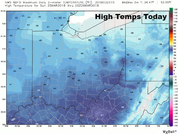
Abundant sunshine will dominate our weather for Palm Sunday ( Today ) with high pressure centered over the upper Great Lakes region. Temperatures this afternoon will remain rather cool for this time of the year, however. Normally we should see highs around 54-55 degrees but we will only top out in the mid 40s in the Ohio Valley today.
Warmer temperatures are headed our way this week. Unfortunately the warmth will be accompanied by periods of rain.
We remain dry tonight with more sunshine headed our way for Monday. The difference will be the warming trend that gets underway tomorrow and we should actually see afternoon highs approach our late March average – mid 50s.
A low pressure system in the Plains will shift east toward the Great Lakes region Monday night increasing our chances for rain showers in Ohio Valley. Rain showers will spread over the area Monday night but with a dry atmosphere in place overhead any rain will have a difficult time reaching the ground – to start.

Eventually, moisture will overcome the dry conditions and light rain showers will become likely Tuesday morning. Sunday ( Today ) morning computer modeling is still in disagreement with the timing of precipitation and this may have an impact on precipitation type as it gets underway here in the Ohio Valley. Chances are that temps will be warm enough to support rain but there is a small chance for some freezing rain to start. I’ll continue to monitor future model runs as they come into better agreement regarding temperatures and timing.
Showers should become more scattered Tuesday night as a slow-moving cold front creeps closer to Ohio Valley. The front will take its good old time crossing the region and showers will likely continue Wednesday into Thursday. The cold front finally exits the region Friday bringing an end to the rain.
Current modeling and the NWS Weather Prediction Center project better than an inch of rainfall through the week ending Friday evening. At this time I think that’s just a little over done given the differences in computer modeling. I do think we could end up with a good inch of rain through the week, though.

Temperatures will remain in the 50s through much of the period until Saturday when things turn cooler behind the cold front on Monday (4/2).
At this time Easter Forecast looks like AM,Showers, PM Sunshine, stay have time to change/update the forecast.


Comments