
Snow Showers this evening & Tonight.Cool & Dry for the weekend.
- Jeffery Kolling Jr.

- Mar 8, 2018
- 3 min read
The sunshine earlier this morning will be brief. Clouds associated with deep upper level low pressure moving across Lake Erie and into central Pennsylvania by this evening. This storm system will drag two waves across Ohio Valley today and provide the focus for two rounds of snow showers.
The first wave will set up around mid afternoon as our storm system moves across Lake Erie. This first round will primarily come from lake effect with the bulk of heavier snow showers keeping to our north. Generally speaking, snow showers that happen to migrate south into Ohio Valley should be light with this first round.

However, I can’t rule out a few squalls containing moderate snowfall migrating far enough south and into our northern Ohio Valley communities. Should these bands materialize, we’ll have to watch for reduced visibility and a quick thump of snow.
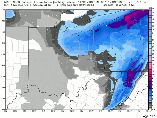
Hi-res Futurecast radar for today through 1:00 am:

Accumulation with this first round will be generally light – not much more than a half inch or so.
We will get a short break and maybe even some clearing ahead of the second – and main wave – associated with this system arrives later this evening and continue overnight. This second batch of snow showers will be more widespread and occur after sunset. Temperatures will drop off to the low 20s again tonight, so snow will be more likely to accumulate.
Early morning modeling suggests that some bands of strong snow showers will be capable of developing with tonight’s snow. These would provide the focus for pockets of heavier snow accumulation.
Both widespread and banded snow will continue into early Friday morning but should begin to diminish by mid morning as winds turn more westerly. Chances for snow will pretty much end by lunch time Friday as drier air works its way into the region.
HOW MUCH SNOW WILL WE GET? We should end up with 1″ to 2″ of snow from these two waves of snow through Friday morning. The bulk of snow will accumulate tonight and Friday morning when temperatures will be more favorable for snow to accumulate on roads and highways.
You could get an inch more in your neighborhood if you happen to get under one of those quick-hitting and unpredictable squalls. Many folks in our area commute for work and school, so keep in mind that snow accumulation and travel impacts will be greater as you head north.
TRAVEL IMPACTS Roads today and for the Thursday evening commute should do well as we’re only expecting light snow this afternoon and evening. However, snow overnight may present some travel concerns for the Friday morning commute. Depending on where the heaviest snow bands set up tonight, there may be some school adjustments. (I do not have anything to do with school delays or cancellations. Please check with your local school or listen to local media regarding school adjustments.) Go to your local news station for the schooling delays & closing.
The pre-treated main roads and highways should fare just fine. Secondary roads will likely be snow covered so we’ll need to be mindful of slick spots Friday morning.
WEEKEND WEATHER Our weather will improve beginning on Saturday as high pressure takes control to dry things out and provide a generally sunny but cool weekend. Saturday will be the pick day with skies gradually clearing to become mostly sunny in the afternoon. Temperatures will remain on the cool side with highs in the low 40s.
In yesterday’s blog I talked about the next system due Sunday evening that the models were in disagreement regarding the track. The last few runs of both the GFS and European models have come into better agreement with this system staying south of Ohio as it crosses east to the mid Atlantic.

While this will bring a cloudier day Sunday, we will stay dry with this storm taking a more southerly track. Temperatures on Sunday will remain in the low 40s.


Comments