
Severe Storm late Afternoon/ Tonight, Flooding,Winds,Hails.
- Jeffery Kolling Jr.

- Apr 3, 2018
- 2 min read
A warm front lifting through east-central Ohio is bringing widespread rain to the region this morning. Rain looks to continue for several more hours until the warm front finally lifts far enough north of the region around mid afternoon. By the time that happens later today we could see an inch to perhaps as much as two inches of rain in the east-central Ohio region.
We should get a short break in the steady rain as the front continues north of the region late this afternoon and early this evening.
On top of the potential for localized flooding, all of this rain will saturate the ground. This could be an important factor later tonight and Wednesday morning when strong gusty winds arrive with a cold front.
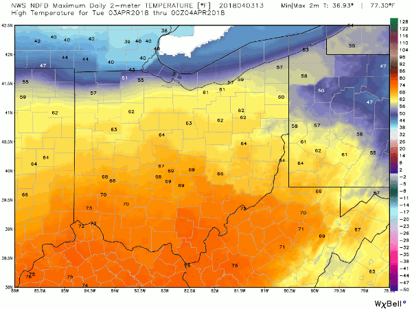
The one and only good thing with today’s weather will be an impressive bump in temperatures today. We’ll see afternoon temperatures reach the mid to upper 60s this afternoon in the Ohio Valley.
STRONG/SEVERE STORMS ARE POSSIBLE THIS EVENING AND TONIGHT Today’s warm temperatures will be brief. A potent cold front will approach and cross east-central Ohio this evening/tonight. Depending on how much clearing and sun we will get in this afternoon and how well the atmosphere can recover from this morning’s rain will determine our potential for severe thunderstorms late this evening.
The NWS Storm Prediction Center has ALL of east-central Ohio highlighted in the Slight Risk category for severe storms late today. Damaging wind gusts are the main threat but hail will also be a possibility with these storms.
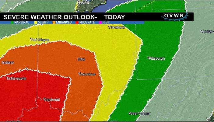
12:30 PM SPC UPDATE | The situation down is southwestern portions of Ohio just got a lot more serious with the midday update from the NWSSPC. That area has been upgraded to a Moderate Risk (4 of 5) for severe storms in the Dayton and Cincinnati areas. The threat for tornadoes (Red areas) there is highly elevated. The SPC indicated that a Tornado Watch is likely for the red highlighted area soon.
Back here in the Ohio Valley, the threat for tornadoes is low but not zero. Remain weather aware today and keep up with the current weather information from a reliable source.
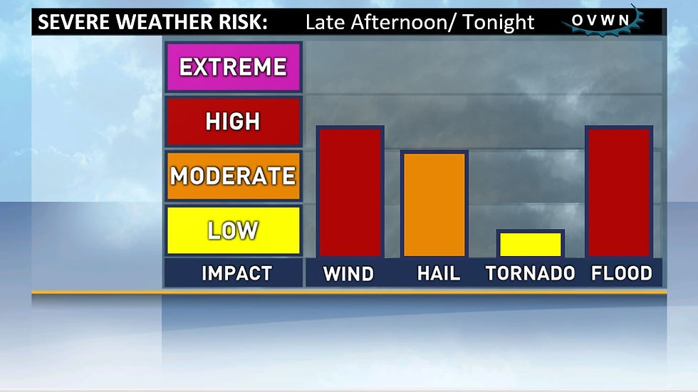
Severe storms or not, winds ahead, along and behind tonight’s cold front will be very strong. Gusts could reach 40 MPH – especially during Wednesday morning. With all of today’s rain saturating the ground, trees will be vulnerable.
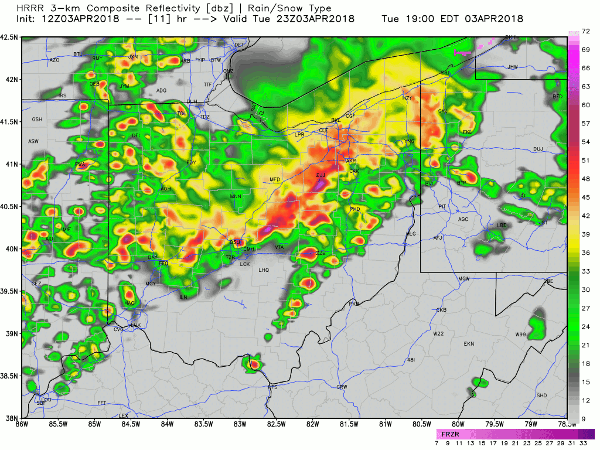
TIMING The greatest threat for severe storms here in the Valley will be around 7:00 PM through midnight. High resolution guidance continues to suggest a line of strong to severe thunderstorms developing to our west and travelling east into the Ohio Valley. While this line of storms will weaken somewhat as it approaches to area, they could still pack quite a punch.
7:00 PM simulated radar product from the HRRR:
WEDNESDAY: FALLING TEMPS, GUSTY WIND Colder and drier air will rush in behind the front on Wednesday bringing an end to showers and storms. Winds will become quite strong with gusts 35/40 MPH during the morning. Winds will diminish somewhat Wednesday night and Thursday but it will remain quite breezy with occasional gusts to 30 MPH.
The warmest temperatures on Wednesday will occur in the morning. Temperatures will fall to the mid 20s by Wednesday night.


Comments