
More Snow tonight through Friday, Below normal Temperatures for the weekend.
- Jeffery Kolling Jr.

- Mar 7, 2018
- 2 min read
Several rounds of snow showers will pummel east-central Ohio Wednesday through Friday as low pressure continues to spin across the upper Great Lakes region. The good news is that while snow showers may be heavy at times this evening, they will be relatively short lived.
Little or no accumulation is expected and road surface temperatures are above freezing so we should see little in the way of travel problems through Wednesday.
The bulk of Wednesday’s snow showers should end shortly after 8:00 pm this evening. The remainder of the night tonight should remain dry as temperatures drop to the low 20s.
Thursday will start out with a lull in activity but snow showers coverage will gradually ramp up during the day.

Another round of snow – this time more widespread – will get underway Thursday afternoon and continue Thursday night. This round of snow showers is more likely to bring accumulating snow to the Ohio Valley mainly Thursday night into early Friday morning. First called 2-3 inches.
Light snow showers will remain possible through Friday morning before winds turn more westerly. High pressure will build in from the west and approach Friday afternoon effectively shutting down the snow machine.
The main highways should fare just fine. Road surfaces remain at of above freezing and road crews should have little trouble treating roads with salt or brine. The secondary roads will likely see more in the way of accumulation so watch out for slick spots.
WEEKEND OUTLOOK By Saturday we’ll find ourselves between systems. Saturday should actually be a nice sunny – but cool – day for the Ohio Valley. More clouds move in by Sunday as as another low pressure system and potential nor’easter travels toward the mid Atlantic.
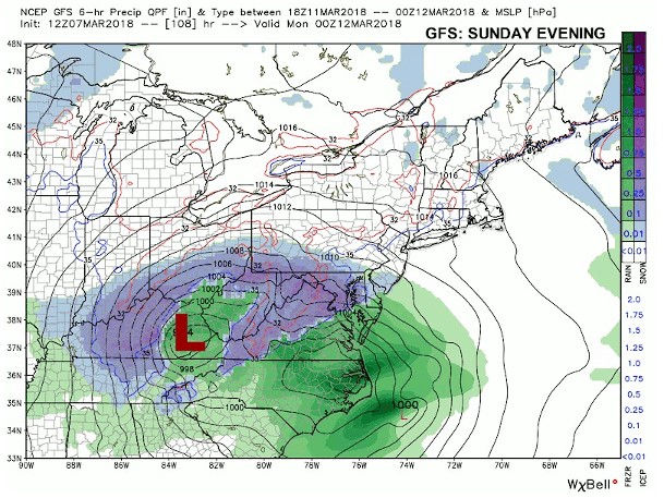
There are some differences in the track of this next low and we will need to keep close watch of the track of this system. The European keeps the system far enough south where it will have little or no impact on east-central Ohio. The GFS (shown above) has a more northerly track which would bring mixed precipitation and snow.
Keep current with the forecast over the weekend. An app is not going to be of much help if the weather is important to you. A small shift west and north could bring drastic changes to Sunday’s forecast.
Stay with us any new updates.
Weather Warnings: https://ohiovalleyweathern.wixsite.com/weather/weather-warnings
If you like to submit video or photo to us. https://ohiovalleyweathern.wixsite.com/weather/weather-watcher


Comments